Natuurmonitoring met AI
This article originally appeared in the online magazine Nature Today on 6-dec-2024.
"Carto" used to be the name of the "Spheer App".
There’s growing attention for the relationship between nature and our daily lives. To manage public space and objectively assess our impact on nature, up-to-date and reliable monitoring is essential. Thanks to remote sensing and artificial intelligence (AI), this monitoring is becoming more accurate and accessible.
Currently, the quality and extent of natural areas and biodiversity in the Province of Groningen are primarily mapped manually by ecologists in the field. While these observations are precise, they are also time-consuming and costly to collect and analyze. Remote sensing and AI now make it possible to gather wall-to-wall, objective, and current information on large natural areas annually—or even more frequently. Over the past decade, the use of satellite data for large-scale, automated monitoring of the Earth’s surface has become increasingly common, often in combination with AI. AI can detect subtle yet relevant patterns from complex datasets.
"With our current software and fieldwork, it can take months before we see results. With Carto’s predictions, we can plan our fieldwork more efficiently and effectively."
Self-learning software
Since 2019, Spheer has been using satellite data to monitor the aging of salt marshes outside the dikes for the Province of Groningen. This involves mapping the spread of sea couch (a dominant grass species) along the entire northern coast and the Dollard. Based on this monitoring, the province can guide management decisions, such as grazing, to prevent sea couch from overtaking these unique (salt marsh) habitats.
In late 2023, Spheer began developing Carto, a tool that allows users to independently perform satellite-based monitoring. As monitoring needs in the province grow, we are exploring new ways to more efficiently and accurately assess the state of Groningen’s nature. That’s why the province is now collaborating with Spheer on the further development and refinement of Carto. Staff from the Nature and data (GIS) departments are testing the tool to see which policy-related monitoring questions it can answer. This partnership enables the province to explore the potential of satellite data monitoring, while Spheer uses the feedback to optimize the platform.
Wat is Carto?
Modern AI can distinguish ground features in satellite images and videos far more accurately than humans. Traditionally, this required large labeled datasets and significant training time. Carto delivers accurate insights and trend data for nature, water, or agriculture, without the need for extensive label datasets.
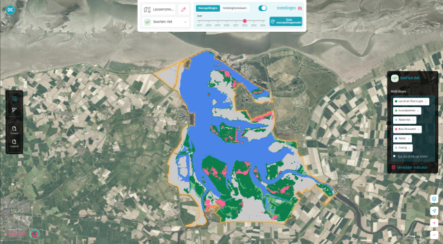
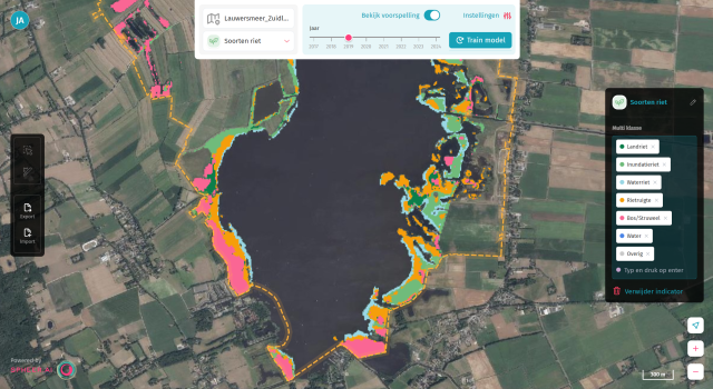
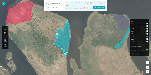
Carto works with user-provided observations: each time you draw an observation, it is automatically linked to the satellite data available for that year. Carto uses satellite imagery with a resolution of 10 meters per pixel, which means that each piece of the map represents an area of 10 by 10 meters. To help the user when drawing observations, aerial photos are shown in the background.
The foundation model developed by Spheer detects patterns in satellite images, having learned from analyzing massive volumes of satellite data to gain deep understanding of the Earth’s surface. When you train a model, you refine this base model using your own observations — essentially creating a custom model for your specific indicator. For example, to monitor reed beds, you label areas with and without reed presence. Carto then trains a model and predicts where reed beds were present from 2017 onward. This enables staff to train satellite-AI models themselves, grounded in field observations. The resulting predictions can be scaled to large areas, and historical maps allow trend analysis over time. During this development phase, results are validated in the field—and early outcomes are promising: Carto makes sea couch monitoring more accurate and accessible than ever.
What do we want to monitor with Carto?
The Province of Groningen hopes to reduce costs and improve efficiency in nature monitoring. With current tools and fieldwork, results can take months. The province has many such monitoring challenges. While field validation and field studies remain essential, Carto’s predictions allow for more targeted and efficient planning.
- We are currently assessing whether this new monitoring technique is suitable for the following monitorint tasks:
- Process indicators for Natura 2000 and SNL-areas, based on vegetation structure: shrub encroachment, reed expansion.
- Dominance stages of specific vegetation types, like sea couch.
- Indicators for (nature-inclusive) agriculture, such as field margins, herb-rich grasslands, and high- vs. low-productivity grasslands.
- Impact assessment of management interventions.
- Invasive species.
- Landscape elements such as hedgerows.
We're also exploring whether AI can identify solar panels, wind turbines, or bike paths. These insights could support work in urban areas by other departments within the province. In the coming months, we’ll continue developing and testing Carto—and we’re eager to see where it will take our nature monitoring.
Text: Diederik van Dullemen, Ruth Lenting-Koffeman, and Jakko de Jong
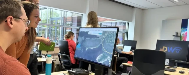
Image: Diederik van Dullemen (lead photo: Nature Monitoring Team receiving a Carto introduction)

