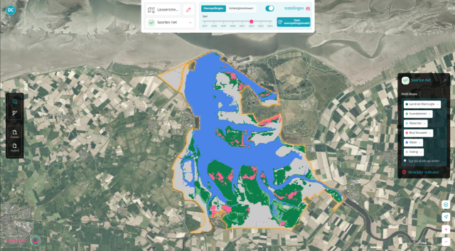
Carto distinguishes reed types around the Lauwersmeer
Provinces experiment with satellite data and AI
This article originally appeared on the website of Binnenlands bestuur on 30 juni 2025.
"Carto" used to be the name of the "Spheer App".
The Groningen-based startup Spheer developed an AI model based on satellite images of the Dutch landscape. With a little training, the model can be used for specific monitoring tasks by governments, for instance to map landscape structures for nature management. Several provinces, including Groningen, are already experimenting with the web application.
Feet in the mud
The first response entrepreneur Jakko de Jong used to get a few years ago when he explained what he planned to do with his startup Spheer was laughter. Or, well, most ecologists are too polite to laugh out loud, but they kindly told him his idea would be of no added value to their work. Ecologists like to have their feet in the mud. They study vegetation down to the square meter. So when De Jong explained that every pixel in his web application Carto represents a 10-by-10-meter area, the reaction was predictable: “That’s useless to us.”
By now, it’s widely understood that an AI model “sees” things very differently.
But that was thinking like a human. By now, it’s widely understood that an AI model “sees” things very differently. Give the model a specific research question and a few examples, and scale is no longer a disadvantage — it becomes a strength. Take the Lauwersmeer and Zuidlaardermeer in the north of the Netherlands. These large peat marshes are hard to access, and the reeds literally grow over the heads of nature managers. “In these areas live bird species that rely on certain types of reeds, like the bittern,” says Diederik van Dullemen, policy advisor for strategic projects at the Province of Groningen. “We’re obliged to ensure proper habitat for these species. Where necessary, we take restoration measures, which we report on to the national government and the EU. We’d really like to gain better insight into the effectiveness of those measures.”
Faster insight into the effects of restoration
It takes several years for the effects of habitat restoration to become visible. Tools to track changes in these areas are limited. In practice, field inspections are done once every twelve years to check whether management measures are working. That fieldwork takes a lot of time — the areas are large, and vegetation is dense.
That’s why Groningen is experimenting with Carto. In the web application, provincial staff mark areas where overgrown reed is definitely present or definitely absent using aerial photographs. The AI model then analyzes satellite data to predict the reed structure in the broader area. Mistakes are corrected, new areas are marked, and the model is fine-tuned until it understands the task. The results from Carto are still validated in the field.
“For a relatively simple question like ours, you don’t need a vegetation specialist who can identify all sorts of plants,” Van Dullemen explains. “We want to know whether there’s reed, whether it’s overgrown reed, or whether the area has turned into woodland. If we can analyze that ourselves in-house, it saves us time and money. And it’s exciting to work with innovative, future-ready tools.”
"If we can analyze this ourselves in-house, it saves us a lot of time and money."
Diederik van Dullemen, Province of Groningen
Self-supervised learning
The AI model behind Carto uses self-supervised learning — a form of machine learning in which a neural network gains knowledge from raw data without human labeling. One example is GPT-4o, the latest AI model behind ChatGPT. This model generates text, calculations, images, and speech based on vast amounts of training data. Spheer’s foundation model isn’t generative AI, but it does recognize patterns in satellite imagery. Because it’s trained on massive amounts of data, the foundation model has developed a deep understanding of Earth’s surface.
“We trained the model using satellite time series videos so it could learn independently what happens on the Earth’s surface,” De Jong says. “It learned how seasons work, how clouds behave, when data is reliable and when it isn’t — for example, when shadows or cloud cover obscure a usable image.” The base data come from the EU’s Copernicus program. So far, Spheer uses all available satellite data over the Netherlands. The next step is to expand to European coverage.
"We trained the model using satellite time series videos so it could learn independently what happens on the Earth’s surface. "
Jakko de Jong, Spheer
Avoiding observer bias
Once the province validates Carto’s results and considers them reliable, the benefits become clear. There’s no need to contract external agencies for field mapping — and no more procurement procedures. Carto also avoids what's known as observer bias. Van Dullemen explains: “Everyone brings their own perspective when drawing on a map or tablet. Humans make different judgments.” A computer may also make mistakes, but at least it’s consistent over time.
The biggest advantage, according to him, is in tracking trends. “The Natura 2000 management plan for the Zuidlaardermeer and Lauwersmeer runs for six years. Within that timeframe, we want to be able to evaluate specific questions. If we can only afford a field survey every twelve years, it’s hard to draw any kind of trendline. But with satellite data, we can compare year zero, year three, and year six. That gives us real insight into how things are going — and lets us adjust faster.”
_________________________________________________________________________________
Free satellite imagery
The Satellietdataportaal of the Netherlands Space Office (NSO), the Dutch government’s space agency, is a database containing up-to-date, high-resolution satellite imagery of the Netherlands. These images can be viewed via an online viewer and are free to access. They complement the open-access satellite data from the Europese Copernicus-programme, which Spheer also uses. While the NSO images offer higher spatial detail, they are updated less frequently, making them suitable for different types of monitoring challenges. Registered users can also access the raw data. Governments use these satellite images for a wide range of purposes—from mobility issues to tracking the origin of nitrogen emissions.


