This article originally appeared in the Groninger Ondernemers Courant on 25 juni 2025.
"Carto" used to be the name of the "Spheer App".
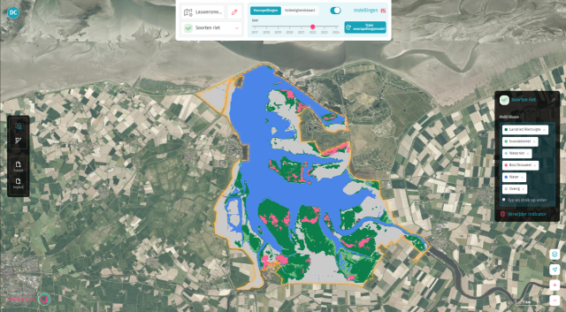
When searching for a specific grass species in a dune area, most people wouldn’t immediately think to use a satellite image: 100 square meters is barely a pixel. But thanks to Carto, the platform developed by Groningen-based AI company Spheer—specializing in biodiversity monitoring—that grass is now easily found. What used to take months can now be done in ten minutes. “Faster and smarter.”
"What ChatGPT does for text, we do for spatial questions," says Jakko de Jong, co-founder of Spheer. The company, founded in 2021 by four AI enthusiasts, develops AI applications for satellite data.
“So really, using AI is a no-brainer.”
Carto
At the core of Spheer’s innovation is Carto, a platform that combines AI with massive volumes of satellite imagery. De Jong explains that since 2016, satellite images of the Earth have been taken every few days. “That’s an enormous amount of data—far more information than the human eye can observe. Think of infrared or UV light.” With AI, those invisible nuances can be detected. “So really, using AI is a no-brainer.”
In short, Carto uses a foundational model trained on massive satellite datasets. Because Spheer built this foundation in-house, users can train a custom model in just a few minutes for their specific needs—such as distinguishing deciduous from coniferous forests. What once took weeks or months is now not only faster, but also significantly more cost-effective.

New platform
As of September 2024, a select group of clients—mostly provinces—began testing the platform. After a successful pilot phase, the first full version of Carto launched in May. A second version is already underway. “Our mission is to make it easy for organizations to use satellite data and AI—without having to install anything or needing technical knowledge of AI or satellite imagery.” This approach is working: many of the public institutions involved in the pilot, including the Province of Groningen, are now regular clients.
Spheer currently focuses mainly on biodiversity monitoring. “There’s a need for it, it can be done better, and it can be done smarter,” De Jong says. Nature is currently surveyed in-depth only once every twelve years. “That makes it hard to identify trends, even though those trends have major consequences—for example, in nitrogen policy.” Carto offers a solution: it shows biodiversity changes across large areas in a transparent and timely way.
Partnership with TU Delft
Recently, Spheer partnered with TU Delft to further explore Carto’s potential. De Jong is optimistic about the future: “With our first product version, we’ve shown we can do something fundamentally new, and we’ve proven there’s demand for it in the Netherlands—so now we’re ready for the next step.”
Finally, De Jong issues a call to entrepreneurs in Groningen: “If you have a spatial challenge you think we could solve more smartly with AI, don’t hesitate to reach out. I’d love to brainstorm with you.”


